John Wood and his brother William Wood, Ship Builders
and Whitehaven in the 18th Century.
Whitehaven Plans and Images in the 18th and Early 19th Century.
The Development of the Harbour.
(Post in preparation).
More information available on my previous post:
https://cumberlandshipbuilding.blogspot.com/2022/11/notes-and-images-of-development-of.html
Whitehaven in 1685. “There were 46 vessels belonging to this port, exclusive of boats, of from 12 to 94 tons, equal to 1,871 tons. The largest of these, the Resolution, of 94 tons, was “commanded by Richard Kelsick, in which he crossed the Western Ocean oftener than once to the province of Virginia, and there took in a cargo of tobacco, and discharged the same at Whitehaven.”
Writing in 1687-8, during the town’s initial phase of expansion, Thomas Denton in his MSS for Sir John Lowther History of Cumberland described Whitehaven thus:
................................
For an important work on "Sir John Lowther and Whitehaven, 1642 - 1706". by Christine Churches 1990, see -
https://digital.library.adelaide.edu.au/dspace/bitstream/2440/19479/2/02whole.pdf
D/ Lons/W unlisted papers - Lists of ships belonging to Whitehaven, 1682 - 1727.
.......................................
In Hutchinson's History of Cumberland, pub. 1794, he states that there were six ship builders yards in Whitehaven, often with 10 or 12 ships on the stocks - he also mentions - Hornby, Bell and Birley who established a sailmakers works at Scotch Street in a former tobacco factory - he also states that output increased from 101 ships in the 1760's to 205 in the 1790's.
____________________
The earliest reference I can find so far to the career of shipbuilder John Wood is that in 1751 John Wood and Henry Benn were granted leave by James Lowther to build ships on land behind Tangier St, Whitehaven.
John Wood would have been aged 34, the age inscribed on the bust (see Coal and Tobacco, Becket pub. 1981 p. 150).
The early life of John Wood prior to 1751 so far remains a mystery. It seems most likely that after leaving home at Yew Tree Farm, Town End, Wilton, Haile he was apprenticed to a Whitehaven ship builder and perhaps went to sea before setting up the yard at Whitehaven.
__________________
For a very useful essay on early Industry in Whitehaven see -
https://digital.library.adelaide.edu.au/dspace/bitstream/2440/19479/2/02whole.pdf
see also
http://www.lakestay.co.uk/whitehavenmininghistory.html
For a list of ships registered in Whitehaven in 1840 see -
http://www.stevebulman.f9.co.uk/cumbria/whitehaven_shipping_f.html
____________________
Prospect of Whitehaven in the year 1642.

View of Whitehaven from the North.
Supposedly 1642. My guess is that it is from a mid 18th century publication.
As yet I have been unable to locate a better version of this engraving. It appears to show pack animals loaded with coal heading for the docks and the ropeworks in the middle ground.
This very poor image from:

Another even worse version of the above engraving from:
https://www.copeland.gov.uk/sites/default/files/attachments/ldfwtcandhwhavenviewsapril2012.pdf
Both are very poor low resolution.

In 1642 Sir Christopher Lowther commenced to export sea salt and coal mined from beneath his estate and shipped to Dublin. by 1700 80% of all Ireland’s coal was imported from Whitehaven.
In 1634 Sir Christopher constructed a pier to provide shelter and to enable the harbour to accommodate his growing fleet of ships. This early pier is incorporated into Old Quay.
During the 1670s the tobacco trade from Virginia developed and by the 1740's Whitehaven had become the second largest tobacco importer in England. However trade decreased markedly after the Act of Union in 1745 came to an end in the 1770s as the American war of Independence ceased importation.
In the early 1700s the harbour continued to develop as the town became a centre for ship building. In 1733 harbour trustees built a new quay known as the Merchants Quay (now the Sugar Tongue) off West Strand. Further improvements followed – the harbour was deepened, New Pier (now the Old New Quay) was constructed in 1740-3 and Old Quay was extended in 1753. a decision was taken by the town’s Harbour Trustees to extend the Western limits of the harbour and as a consequence West Pier was constructed between 1830 and 1838.
Daniel Defoe - description of Whitehaven.
Tour through England and Wales, by Daniel Defoe, published in parts, London, 1724-26.
"Under this shore, the navigation being secured by this cape of St. Bees, is the town of Whitehaven, grown up from a small place to be very considerable by the coal trade, which is encreased so considerably of late, that it is now the most eminent port in England for shipping off coals, except Newcastle and Sunderland, and even beyond the last, for they wholly supply the city of Dublin, and all the towns of Ireland on that coast; and 'tis frequent in time of war, or upon the ordinary occasion of cross winds, to have two hundred sail of ships at a time go from this place for Dublin, loaden with coals."
"They have of late fallen into some merchandizing also, occasioned by the great number of their shipping, and there are now some considerable merchants; but the town is yet but young in trade, and that trade is so far from being ancient, that Mr. Cambden does not so much as name the place, and his continuator says very little of it."
................................
The Gentleman's Magazine or Monthly Intelligencer or Historical Chronicle, published by Edward Cave under the pseudonym Sylvanus Urban, and by other publishers, London.
Gentleman's Magazine, 1748 p.5.
"After a fine coast and inland, we came to Whitehaven, which is a thriving and well-built town; it exceeds Carlisle in extent about ⅓, but is thrice as populous. The streets are extremely straight and regular in most places; there is a general appearance of industry amongst the inhabitants, and the hurry and bustle which accompanies their trade seems to be natural and easy. The vast supply of coals in this neighbourhood has rais'd this port from a fishing town to be the next after Bristol and Leverpool on the west sea, and the roads leading to it are equal to the best turnpikes about London, and are every-day improving, and carrying forward. Its situation is low in comparison of the great height of the coast on all side of it, and the harbour barricado'd with several piers to bridle the fury of the west winds, to which it is greatly expos'd. Here the country puts on a much better appearance, and a fine vale encircles Bees-head from Whitehaven to the little brook below Sea-cote, full of pleasant villages, and country seats; so that if you have no accident by the way in so long a journey, you will not repent visiting Whitehaven."
"There is a small fort at the outer pier, to command the harbour, of no great strength by situation; there seems wanting a lower battery on the pier itself."
____________________
Camden’s Britannia, 1789 (Gough Additions).
Britannia, or A Chorographical Description of the Flourishing Kingdoms of England, Scotland, and Ireland, by William Camden, 1586, translated from the 1607 Latin edition by Richard Gough, published London, 1789.
Page 180.
"Below St. Bees and in its parish is Whitehaven a handsome regular town, so called from the white rocks and cliffs. It is chiefly beholden for its improvement to sir John Lowther, who took his title of distinction from it, and whose descendants have a considerable estate here. It contains 1200 inhabitants, and has 190 great ships, mostly employed in the coal trade; three chapels, four meeting-houses, and a good artificial harbour with a long pier. The collieries lie at the foot of an hill 80 fathoms deep, by an easy descent bricked and vaulted. The town and collieries produced a revenue of 16,000 a year to the late sir James Lowther, who had here a magazine of oats, which he always sold to the colliers at 5s. per bushel Cumberland or three Winchester measure"
"Whitehaven in 1566 had but six houses and only one pickard of eight or nine tons; in 1582 twelve small ships. Sir Christopher, 2d son of sir John Lowther, purchased the lands of St. Bees priory here, and settled here and died 1644. The late sir James lived to see about 11000 inhabitants, and about 260 sail ships of near 30,000 tuns burthen. Thirty of them are employed in foreign trade and the rest in the coal trade, and export yearly above 20,000 tuns. He devised his estates here to sir William Lowther of Holker, bart. who dying the next year was succeeded in the said estates, reckoned 14,000£. a year, by the present sir James Lowther, created earl of Lonsdale 1780. ..."
_____________________
Between the 1730's and 1750's tobacco apart from coal was one of the chief imports into Whitehaven from Virginia and was then re exported all over Europe, but from the 17th Century the export of coal particularly to Ireland formed the mainstay of its economy throughout the century.
1751. John Wood and Henry Benn were granted leave by Sir James Lowther to build ships on land behind Tangier St, Whitehaven (see Coal and Tobacco p. 150).
This is the first mention of John Wood in relation to shipbuilding at Whitehaven, at present his earlier life remains shrouded in mystery. Perhaps he went to sea but he is most likely have served an apprenticeship with one of the Whitehaven ship builders.
Most internet searches bring up John Wood of Workington, but also of Harrington which is just a few miles up the coast from Whitehaven and a couple of miles south of Workington.
The name Benn appears frequently when researching early Whitehaven merchants, as does those of Spedding, How, Lutwidge, Younghusband and Kelsick etc.
John Wood's father John and his mother Elizabeth nee Kelsick had property at Yew Tree Farm, Town End, Wilton, Haile (Hale) just east of Egremont. see map below.
______________
In 1762 John Wood was living with members of his family in Ropers Alley, now Coats Lane, between Queen Street and Ropers Lane, Whitehaven.
This information comes from a transcription of a 1762 town census at Whitehaven Archives
............... .
Both John and his brother William Wood were living at the premises in Ropers Alley, later called Coats Lane.
In a letter to Dr Crerar in the Crerar Files at Carlisle, written by a Mr Hay at Whitehaven in 1939, Will. Wood, carpenter was residing in a front house in Coats Lane but in the column for the number of inmates there was a zero, however in the line above, John Wood is described as carpenter and there were 9 inmates in the house - Mr Hay also suggests that William Wood had other properties in the town but a brief search would suggest that the other Woods in Whitehaven were not closely related.
More research needed on Ropers Alley?/ Coats Lane.
This is confirmed in a transcribed copy of a census taken in 1762 (Whitehaven Archives).
Ropers Alley appears on the early plans of Whitehaven by Pellin but as yet we have no record of when the Woods moved to the property.
_________________
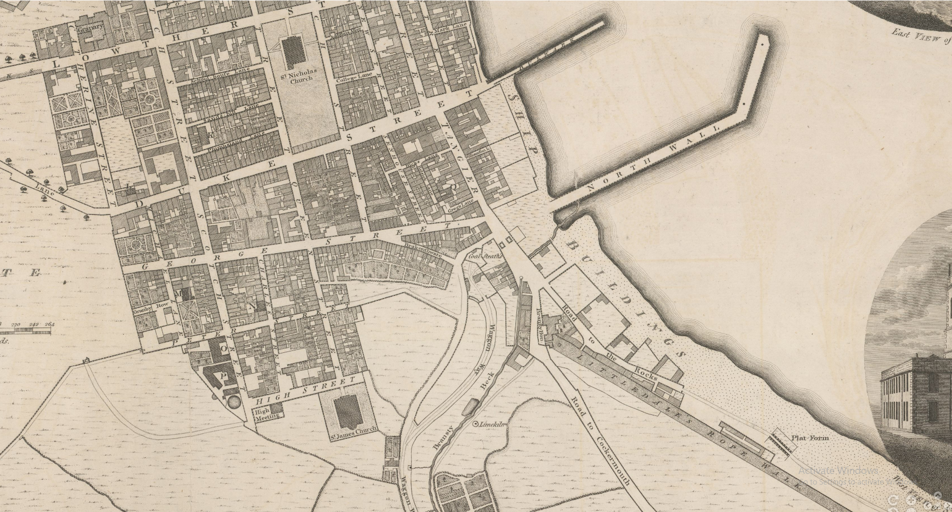
Locating the Wood family home Ropers Alley/ Coates Lane Whitehaven home of the Wood family in 1762


Coates Lane Running between Roper Street and Queen Street.
Ordinance Survey c. 1869.
National Library of Scotland.
_______________

Whitehaven as Built and Projected. c1690, Cumberland, published by the Cumberland and Westmorland Archaeological and Antiquarian Society, 1877.
image from https://www.lakesguides.co.uk/html/maps/M006P.htm

Andrew Pellin's Plan of Whitehaven 1705.
_____________

Andrew Pellin's Plan of Whitehaven 1705.
Crop showing Ropers Alley/ Coates Lane, between Ropers Lane and Queen Street.
____________________________

_
Central Whitehaven, 1710.
Showing Ropers Alley/ Coates Lane, between Ropers Lane and Queen Street.
The home of the Wood family appears to be on the South side of Ropers Alley on the corner of Queen Street showing two wings (one facing Queen Street). and with a forecourt - this needs to be confirmed.
If this is the case the buildings of the Wood's property were demolished and replaced with the building of the Whitehaven Bank.
https://www.natwestgroup.com/heritage/companies/whitehaven-joint-stock-banking-co-ltd.html
An article in the Cumberland Pacquet of May 17, 1786 announces that the partners of this Bank would be John and Thomas Hartley, Henry Littledale and Samuel Potter along with a Mr Harrison, of London, and that the bank would open in Coates Lane.
The Hartleys were a well known local family who had had a rope and twine manufactory in the town since the 17th century. They were also ship owners”.
Milham Hartley (1771 - 1839) was one of the founders of the Joint Stock Bank of Whitehaven in 1818, originally Hartley’s Bank founded 1786 by his father and uncle John and Thomas Hartley [although the RBS Heritage site shows the conversion to a joint stock bank only in 1837]: he was certainly a partner in the bank.
Milham Hartley's principal business was the Ropery at Corkickle/Coach Road, Whitehaven. business sold 8 May 1856. The Corkickle Ropery was taken over by Brocklebanks the Whitehaven shipbuilders.
YDX 309/12, Hartley family papers - Correspondence, papers, copy documents, articles and photographs relating to the Hartley family of Whitehaven, Gillfoot and Moresby 17th & 18th century.
The Ropers Alley/ Coats Lane property still belonged to Sarah Wood d. 1807 (the wife of John Wood) in 1807 when it was bequeathed to their son John (The Reverend).
_____________________________

Plan of Whitehaven, 1774.
Thomas Donald. Engraved and published by Joseph Hodkinson, 29 Arundel Street, Strand, London, 1774.
NB. Roper Alley now Coates Lane.
Image courtesy - https://www.lakesguides.co.uk/html/lgaz/lk12565.htm
_______________________

John Howard's 1791 Map of Whitehaven showing Location of Ropers Alley/ Coats Lane.
South is towards the top of the map.
E is the later Bank building (Messrs Hartley & Co's Bank in 1834).
see -
https://curiosity.lib.harvard.edu/scanned-maps/catalog/44-990136134690203941
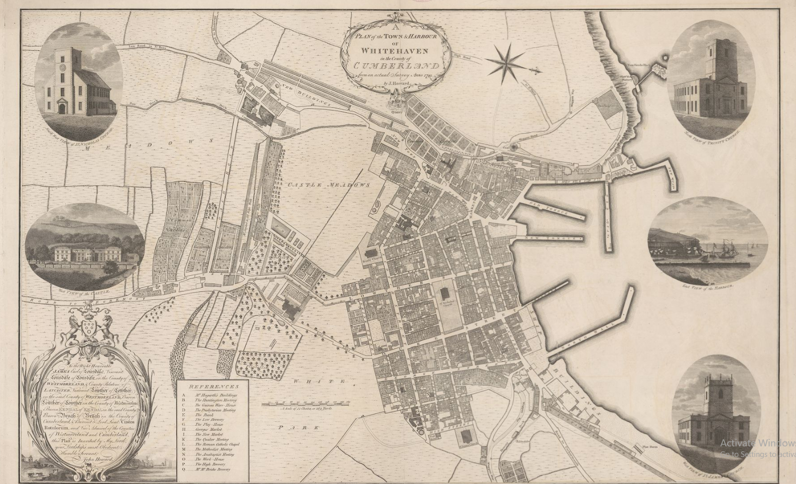
High resolution images can be viewed on the website.
___________

An Old photograph of Coates Lane.
I don't think the Woods house is depicted here.
_________________


Thomas Kitchen.
1777.
_________________
Some Early Illustrations of Whitehaven.

Unknown painter.
Source of image: http://www.cumberlandscarrow.com/whitehaven.htm
_________________

A Bird's-Eye View of Whitehaven.
Matthias Read (1669–1747).
The Beacon Museum, Whitehaven.
Annoyingly low resolution from Art UK website.
____________

A Bird's-Eye View of Whitehaven.
Matthias Read (1669–1747).
84 x 118 cms approx.
Tullie House Museum and Art Gallery
Photo courtesy and text here Art.UK
Four views of Whitehaven by Read survive. This painting is the earliest and plainest example which shows only one pier in the harbour and a small number of ships. The town is still very small and details of the buildings are unfinished.
Whitehaven was the earliest planned town in England thanks to the vision of Sir John Lowther (1642–1706), the local landowner, who built up his wealth in coal. The groups of locals dancing and drinking in the foreground of the painting bring life to the scene. The small red and yellow stripe of paint is a mystery.
__________
Matthias Read
71 x129 cms
Beacon Museum. Whitehaven.

Whitehaven.
Matthias Read.
Image courtesy Bonhams Auctions.
24 Oct. 2018.
54 x87.5 cms.
________________

A Bird's-Eye View of Whitehaven.
Matthias Read (1669–1747)
101 x 182 cms approx.
Yale Centre for British Art
For an essay on this painting see -
For the engraving of 1738 by Richard Parr and details see below.
Whitehaven after Matthias Read - 1738.


Images above Richard Parr after Matthias Read.
Whitehaven.
1738.
Inscribed -
To the Honble. SR. JAMES LOWTHER BART. F.R.S. & Knight of the Shire for the County of CUMBERLAND this East Prospect of the Town and Harbour of WHITEHAVEN, is humbly Inscribed. / R. Parr Sculp.

Plan of Whitehaven.
South is to the right of the plan.
Made by Carlyle Spedding 1752
Whitehaven Archives TCBN / plans / 24 - 4.
Annoyingly low resolution
It appears to show the town and surrounding area divided into squares.
From CASCAT on line catalogue.
I hope in due course to get a higher resolution image.
_________________
Plan of Whitehaven
John Howard 1791
https://curiosity.lib.harvard.edu/scanned-maps/catalog/44-990136134690203941


__________________________

Daniel Lysons and Samuel Lysons, 'Whitehaven', in Magna Britannia: Volume 4, Cumberland (London, 1816), pp. 22-26. British History Online
http://www.british-history.ac.uk/magna-britannia/vol4/pp22-26

Graving banks were used where “graving” took place. To “grave” a ship originally was a process of smearing a residue of boiled tallow and resin onto her hull . Eventually the term was used for any area where a ship was overhauled, or even for dry docking. Pitch and tar mixtures were also employed.

For Sir John Lowther and Whitehaven, 1642-1706 : the relations of a landlord with his estate / University thesis by Christine Churches see -
https://hdl.handle.net/2440/19479
______________
Wood's Plan of Whitehaven, 1832.

This crop shows the yards of T and I Brocklebanks, Brocklebanks Ropery, Scott and Whitesides, William Wilson and Company and the East Strand yard with the patent slip.


Whitehaven. 1806.
from Lyson's Magna Brittania 1806.
Drawn by Joseph Farrington etched by Letitia Byrne.
View from the South.
Detailed crop below.

____________________

_________________________________
For the current Whitehaven Town Centre and High St Conservation Areas see:
https://www.copeland.gov.uk/sites/default/files/attachments/ldfwhaventcandhstcapra09.pdf
Whitehaven: Seeing the History in the View – Excellent document giving a good overview of history and buildings
https://www.copeland.gov.uk/sites/default/files/attachments/ldfwtcandhwhavenviewsapril2012.pdf
_______________


From the Present State of Ship building in Great Britain - 1814.
Available on line - see -
https://babel.hathitrust.org/cgi/pt?id=umn.319510021011122&view=1up&seq=7&skin=2021
____________________
A List of Ships Registered at Whitehaven in 1828.
List Prepared from Sawyers List of 1828 by Dr Crerar now in Carlisle Archives.
Another later Sawyers. List of 1840 is available.
Reprinted by Moons Bookshop of Whitehaven
The Wood family built ships underlined in red.
The earliest Wood ship is the Endeavour built by John Wood at Rockliffe (near Carlisle) in 1750.


No comments:
Post a Comment